Turbulence Discussion
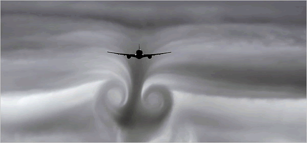
Turbulence is an irregular movement of air in the atmosphere that creates wind gusts and sharp, quick updrafts and/or downdrafts that can occur in combinations and, can quickly and unexpectedly change the flight characteristics of the aircraft. This unexpected air movement can cause serious damage to aircraft and potentially injure aircrew members and passengers. It is important to understand the causes of turbulence to be able to forecast the phenomena correctly.
Turbulence Categories
There are four categories of turbulence severity. Keep in mind that the severity of turbulence is dependent on the aircraft in question.
- Light - Turbulence that momentarily causes slight, erratic changes in altitude and/or attitude (pitch, roll, yaw). Occupants may feel a slight strain against seat belts or shoulder straps. Unsecured objects may be displaced slightly. Food service may be conducted and little or no difficulty is encountered in walking.
- Moderate - Turbulence that causes rapid bumps or jolts without appreciable changes in aircraft altitude or attitude. Occupants feel definite strain against seat belts or shoulder straps. Unsecured objects are dislodged. Food service and walking are difficult.
- Severe - Turbulence that causes large, abrupt changes in altitude and/or attitude. It usually causes large variations in indicated airspeed. Aircraft may be momentarily out of control. Occupants are forced violently against seat belts or shoulder straps. Unsecured objects are tossed about. Food service and walking are impossible.
- Extreme - Turbulence in which the aircraft is violently tossed about and is practically impossible to control. It may cause structural damage.
Turbulence Effects
Turbulence affects aircraft performance in several different ways. For better customer support, you need to understand the effects of turbulence on airframes.
- Turbulence is directly proportional to the speed of the aircraft. This means that the faster the aircraft flies in a turbulent area, the more turbulence it experiences.
- Turbulence is inversely proportional to the weight of the aircraft; i.e., the heavier the aircraft, the less turbulence it experiences.
- Turbulence is directly proportional to the wing area (or arc of the rotor blade for helicopters) of the aircraft. The greater the distance between the leading edge of the aircraft wing or rotor blade and the trailing edge, the greater the turbulence experienced.
- Turbulence is inversely proportional to the lift velocities of a rotary wing aircraft. This means that helicopters with slower lift velocities are associated with greater turbulence, and faster lift velocity helicopters are associated with less turbulence.
Turbulence Types
Turbulence, for our purpose, can be divided into three different types based on how the turbulence forms. They are thermal/convective turbulence, frontal turbulence, andmechanical turbulence.
The following is a chart for forecasting low level turbulence and wind shear.
Mechanical Turbulence
Mechanical turbulence is caused by horizontal and vertical wind shear and is the result of pressure gradient differences, terrain obstructions, or frontal zone shear. The three types of mechanical turbulence discussed in this module are clear air turbulence (CAT), mountain wave (MW) turbulence, and wake turbulence.
Clear Air Turbulence (CAT)
CAT includes turbulence not associated with visible convective activity. It includes high-level frontal and jet stream turbulence. It may also occur in high-level, nonconvective clouds. CAT significantly impacts aviation.
Mountain Wave Turbulence
Mountain wave turbulence is the most severe type of terrain-induced turbulence. If the dynamics are favorable for the formation of mountain wave turbulence, the wind flowing over the hills and mountains is set into smooth oscillation. This oscillation can become so vigorous (in terms of intensity) it frequently produces severe to extreme turbulence. For this reason, it is critical to accurately diagnose the initial onset phase of mountain wave turbulence, so those aviators can have an adequate warning as to the potential development of this highly hazardous condition.
Wake Turbulence
The last sub-type of mechanical turbulence that we will discuss is wake turbulence. Wake turbulence is becoming a more common problem with the increased use of heavy aircraft. Wake vortices are primarily a product of lift. They roll off the wingtips and trail behind the aircraft. Heavy, slow, and aerodynamic aircraft produce the strongest vortices. Although both neither forecast nor recorded in a TAF, wake turbulence is a problem and you should be aware how wake turbulence forms as well as its effects.
CAT Forecasting
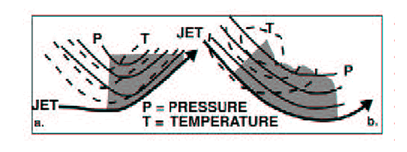
Open Isotherm Troughs
This situation encompasses the majority of the CAT patterns. The noticeable bulging of a cold-air tongue in a relatively tight thermal gradient may occur at or near the bottom of the trough. In either case, the isotherms curve more sharply than the contours (see figure below). In both cases, moderate turbulence was reported between FL250 and FL350.
Aircraft Icing General Information
Aircraft icing is one of the major weather hazards to aviation. Icing can be divided into two categories, external and internal. External icing is the accumulation of ice on the exposed surfaces of aircraft when flown through supercooled water drops (cloud or precipitation). Internal icing (icing of the intake, carburetor, or engine icing) literally reduces the breathing of the engine, which results in a loss of power.
Icing Types
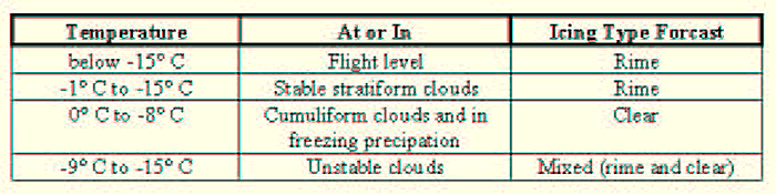
Aircraft icing varies considerably in density, transparency, and hardness. Temperature,drop size, and rate of accretion (accumulation or buildup) control these variations. Frost, rime ice and clear ice are the three basic forms of aircraft icing. . In addition, mixtures of rime and clear ice are common--resulting in “mixed” icing. Two basic conditions must be met for dangerous amounts of ice to form on an airframe. First, the aircraft surface temperature must be colder than 0° C. Second, supercooled water droplets (liquid water droplets at subfreezing temperatures) must be present. Water droplets in the free air, unlike standing water, do not freeze at 0° C. Instead, the freezing temperature varies from an upper limit near -10° C to a lower limit near -40° C. Therefore, the possibility of icing must be anticipated in any flight through supercooled clouds or liquid precipitation at temperatures below freezing. Figure 7-4 can be used as a basic guide of icing determination. As mentioned earlier, there are three basic forms of ice accumulation on aircraft: rime ice, clear ice, and frost. While in flight, an aircraft can experience any of the three. The form of icing depends primarily on the droplet size and temperature.
Rime
Rime ice is rough, milky, and opaque. The granular texture exists because the ice forms when very small droplets freeze almost instantly upon striking the aircraft and trap air between the spherical drops. Rime ice is most frequently associated with stratus clouds at temperatures between -8° C and -10° C, although it has been observed to form between -2° C and -30° C. In comparison to clear ice, rime ice is relatively easy to get rid of by conventional deicing methods.
Clear
Clear ice is glossy or translucent and is formed by the relatively slow freezing of large supercooled droplets. The large droplets spread out over the airfoil before complete freezing and form a clear sheet of ice. This ice is formed in cumuliform clouds and is the result of larger drops that are usually between 0° C and -16° C. Freezing precipitation also generates clear icing.
Frost
Frost is a light feathery deposit that occurs when moist air above 0° C passes over a surface that is below 0° C. An aircraft may collect frost when it is descending from cold air (below 0° C) into warmer, very moist air in lower layers. Frost may form during the night when the temperature of the aircraft skin is below freezing. Frost can cover the windshield or canopy and completely restrict outside visibility or it may form on the inner side of the canopy.
You can teach your students to use the chart below to forecast the type of icing.
Icing Intensities
It is critical that we accurately forecast not only the type of icing, but the intensity as well. Most aircraft can handle light icing if they have deicing capabilities. However, as the icing intensity increases, more and more aircraft have problems. Let’s take a look at the different intensities of icing and how they affect an aircraft’s deicing capabilities.
- Trace - Trace icing is perceptible, but the rate of accretion (growth) is approximately balanced by the rate of sublimation. It is not a hazard unless encountered for extended periods of time (over one hour). The use of deicing equipment is usually not necessary.
- Light - The icing rate of accretion is such as to create a hazard if the flight is prolonged in the icing zone (typically over one hour), but insufficient to make immediate diversionary action necessary. Occasional use of deicing equipment is needed.
- Moderate - The excessive rate of icing accretion makes even short encounters with these conditions hazardous. Diversion is necessary or continuous use of deicing equipment required.
- Severe - Icing conditions are such that deicing equipment fails to reduce or control the hazard. Immediate diversion is necessary.
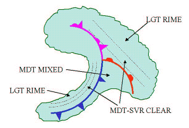
Most moderate and severe icing occur in Thunderstorms (assume Severe) and around frontal systems. See the figure below for icing locations in frontal systems.