Temperature
A temperature forecast is one of the most frequently requested services that you will provide. Temperature plays a big role in the lives of every person on installations or in the field. Air temperature affect the abilities of people trying to accomplish the mission as well as the equipment they operate, so it’s very important to forecast this phenomena accurately. There are several factors to consider when it comes to forecasting air temperatures. They are insolation and radiation, advection, mixing, and adiabatic process.
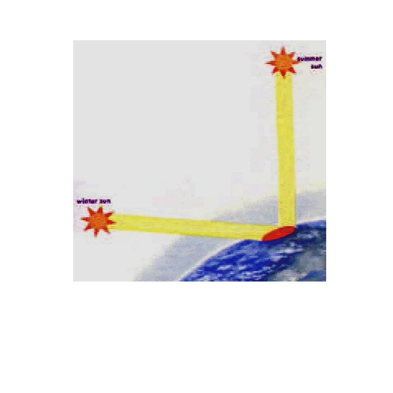
Insolation and Radiation
Insolation is defined as the incoming solar radiation that reaches the earth or atmosphere. Insolation is probably the biggest factor when considering the temperature forecast. Stations at low latitudes (closer to the equator) receive more heat during the day than stations at high latitudes (closer to the poles). Expect more daytime heating in the summer months than in the winter months, since during the summer months the sun's rays are more direct and reach the earth for a longer period of time (see figure below). Normally, there is a net gain of heat during the day and a net loss at night. Consequently the maximum temperature is usually reached during the day, and the minimum at night.
Effects of Cloud Cover on Insolation
Cloud cover affects how much insolation reaches the earth’s surface. Temperature forecasts must be made only after the amount of cloudiness is determined. Clouds reduce the amount of short-wave radiation reaching the surface of the earth and thus reduces the amount of terrestrial radiation reflected back into the atmosphere causing daytime temperature readings to be relatively lower than normally expected. Cloud cover at night will prevent the escape of terrestrial radiation into space and cause the retransmission of long wave radiation from the cloud bases back towards the surface, much like a greenhouse. This causes the nighttime temperatures to be relatively higher. The stability of the lapse rate has a marked effect on insolation and terrestrial radiation. With a stable lapse rate, there is less vertical extent to beat; therefore, surface hearing takes place more rapidly. The opposite is true with an unstable lapse rate. An inversion results in less cooling, since the surface temperature is lower than that of the inversion layer; that is, at some point the energy radiated by the surface is balanced by that radiated by the inversion layer.
Effect of Snow Cover on Insolation
As incoming solar radiation reaches the earth's surface, much of it is absorbed and reradiated. This causes air near the earth’s surface to warm. If snow is present on the ground, some of the sun’s energy melts the snow, but a lot of radiation is reflected away by the snow as shortwave radiation that doesn’t heat the air (see Figure 4-2). The combination of these two factors means that there is less energy available to heat the earth’s surface. The temperatures will rise more slowly than they would if there was no snow on the ground.
Advection
One of the biggest factors affecting temperature is the advection of air. Advection is particularly marked in its effect on temperature with frontal passage. If a frontal passage is expected during the forecast period, the temperature must be considered. Advection within an air mass may also be important. This is particularly true of sea and land breezes and mountain breezes. They affect the maximum and minimum temperatures and their time of occurence.
Air Pressure
The weight of the air molecules that surround us exerts force on the earth’s surface. The amount of force exerted over an area of surface is called atmospheric pressure or simply air pressure. The pressure at any level in the atmosphere may be measured in terms of the total weight of the air above any point. As we climb in elevations, fewer air molecules are above us; hence, atmospheric pressure always decreases with increasing heights. The three major parameters used to determine correct height are altimeter settings, Dvalues, and pressure altitude. Occasionally, you may be asked to provide a fourth parameter, density altitude for heavy airlift and rotary aircraft missions at high altitude and/or high air temperature locations.
Altimeter Setting (ALSTG)
An altimeter is an barometer calibrated to indicate altitude instead of pressure. When the altimeter is properly set, the altitude indicated corresponds to the equivalent pressure in the standard atmosphere. Thus, the altimeter is always indicating a pressure height and not an actual height. For example, when the aircraft is flying at the 500 mb surface, the altimeter indicates that the height in MSL of the aircraft is 18,289 feet, whether it is or not. As you probably realize, this can create hazards for both the pilot and forecaster who are not careful in determining altimeter settings and setting altimeters accordingly. The major errors in altimeter settings come from the difference of the actual atmosphere from major errors in altimeter settings come from the difference of the actual atmosphere from the standard atmosphere caused by temperature and/or pressure. At and above FL180 (18,000 feet mean sea level), where height above ground level (AGL) and in most locations terrain avoidance is not a primary concern, pilots are required to set their pressure altimeter to 29.92 inches of mercury (in Hg). This standard mean sea level (MSL) pressure is used to ensure proper aircraft separation in the vertical. Below FL180, pilots use observed and forecast altimeter settings to ensure that their actual height AGL is known.
Pressure Altitude (PA)
The PA is the elevation in the standard atmosphere at which a given pressure occurs. Most aircrews require PA to calculate takeoff and landing performance. The formula for calculating PA, using a given altimeter and the field elevation (FE), in feet, is:
PA = FE + [1000 (29.92 - QNH)]
In the formula, QNH is the forecast or observed altimeter setting. For example, let’s say that the PA for your airfield is +3,000 feet. This means that any aircraft landing or departing performs as though it is at 3,000 feet of elevation, no matter whether the field elevation is 3,000 feet or not. The PA is easily computed. All you need is the field elevation and the altimeter setting.
Use the step-by-step procedures below for computing the PA. Use a field elevation of+750 feet and an altimeter setting of 30.02 as an example:
Step 1: Subtract the altimeter setting from 29.92.
29.92 – 30.02 = –0.10
Step 2: Multiply the answer in Step 1 by 1,000.
–0.10 X (1,000) = –100
Step 3: Add the answer in Step 2 with the field evaluation.
–100 + 750 = 650
Therefore, the pressure altitude is +650 feet.
This method can be used to compute the PA for an airfield since you know the field elevation and the altimeter setting for the time of concern. Suppose you want to computethe PA for an airfield with a field elevation of +330 feet and an altimeter setting of 29.76.
The same procedures are applied.
· Step 1: 29.92 – 29.76 = 0.16
· Step 2: 0.16(1,000) = 160
· Step 3: 160 + 330 = +490 feet