Forecasting restrictions to visibility caused by precipitation is a function of precipitation type and intensity. For precipitation to occur, two basic ingredients are necessary: moisture and a mechanism for lifting to expand and cool the air sufficiently to promote condensation. Lifting mechanisms include convection, orographic lifting, and frontal lifting. There are many techniques and methods available for forecasting precipitation.
Precipitation and Frontal Systems
Before you get into the precipitation forecast rules of thumb and techniques, you must understand the relationship between precipitation types, intensities, and amounts associated with frontal systems. Frontal systems do not have the same sequence of weather every time, but in the “classic” systems covered, you should get a feeling of how to forecast for the different types of fronts.
Cold Fronts
There are two types of cold fronts: slow moving or active cold fronts and fast moving or inactive cold fronts. You can quickly identify an active cold front by looking at the upper wind flow. The upper winds are parallel to the front, as are the isotherms. An inactive cold front will have the upper winds perpendicular to the front and the isotherms are not parallel, but are at an angle of about 30° to the front, usually crossing the cold front near its junction with the associated warm front.
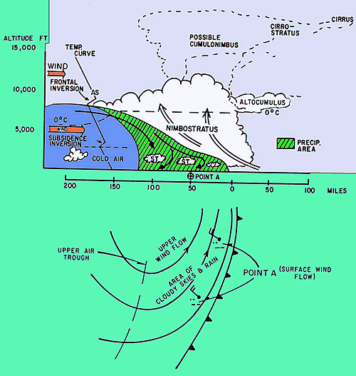
Active Cold Fronts
With the slow moving cold front, there is a general upward motion of warm air along the entire frontal surface with pronounced lifting along the lower portion (closest to the surface) of the front. This results in widespread frontal cloudiness and precipitation at and behind the front caused by actual frontal lifting.
The weather associated with the slow moving active cold front is dependent on the stability of the warm air mass.
· If the warm air is stable, a rather broad zone of altostratus and nimbostratus clouds will be accompanied by light to moderate rain, drizzle, and/or snow, provided there is sufficient moisture available. This type of weather may extend several hundred miles behind the front.
· If the warm air is unstable (or conditionally unstable), thunderstorms, rain and/or snow showers may develop within the cloudbank and may stretch up to 50 miles behind the surface front.
Please see the figure below for an example of an active cold front.
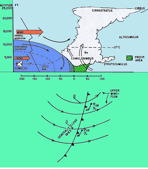
Inactive Cold Fronts
Inactive or fast moving cold fronts have a very steep frontal slope. This causes the warm air near the surface to be forced rapidly upward. At higher levels, air flows rapidly down the surface front and collides with the rising air near the surface. This causes a relatively narrow but often violent band of weather ahead of the front. The fast moving cold front is considered inactive because the lifting occurs only along and ahead of the front. If the warm air is moist and unstable, a line of convection develops 50 to 200 miles ahead of and parallel to the surface front. If the surface convergence is strong enough, often a squall line with powerful thunderstorms, heavy rainshowers and possibly large hail may develop. If the warm air is stable, an overcast layer of altostratus clouds and light, steady precipitation may extend over a large area ahead of the front. Behind the front, unless the cold air is unstable and descending currents are weak, there are few clouds and little if any precipitation.
Please see the figure below for an example of an inactive cold front.
Warm Fronts
Steady precipitation is usually common with overrunning condition and the accompanying stratified clouds. Intermittent or continuous rain/snow is common as far as 300 miles ahead of a warm front. Surface rain, drizzle and snow are associated with the nimbostratus in the warm air above the frontal surface and with stratus in the cold air. If the warm air is convectively unstable, showers and thunderstorms may occur in addition to the steady precipitation. The amount and type of precipitation vary with the characteristics of the air masses involved and depending on whether the front is active or inactive.
Fog Forecasting
The following parameters and conditions have to be considered if you think that fog may reduce visibility:
- The synoptic situation
- Time of the year
- State of the earth's surface
- Station climatology
- Stability of the lapse rate
- Stability of the lowest 50 to 150 mb of the atmosphere
- Temperatue
- Dew point depression
- Amount of cooling
- Winds
- Wind direction
- Wind Velocity
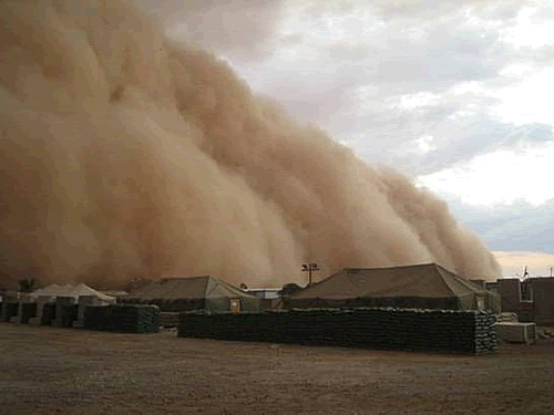
Forecasting Sandstorms
METSAT data is vital when trying to forecast sandstorms.
For significant quantities of sand and dust particles to be uplifted in the air, a threshold value for wind speed ranging from about 5 m/s in desert areas to a value close to 10 m/s in semi-arid regions would be required. Following extensive consultation with experts from desert regions (Bahrain, Arabian peninsula), and being fully aware that visibility in sandstorms and dust storms may be influenced by the optical characteristics of the aerosols (chemical composition, particle size spectra) and lighting conditions (solar azimuth, background luminance, presence of medium or high cloud), the following thresholds, which are familiar to human observers and automated systems alike, could be used:
VIS<1000m visibility and mean speed of >=20 kt for a "light" sandstorm or duststorm, with the sky being visible ( not to be reported in SPECI)
VIS <600m visibility for "moderate" sand –and dust storms
VIS <200m and for "severe/heavy" sandstorm or duststorm, with the sky being obscured in these cases. (Puempel, 2010).
So seeing the upstream conditions and forecasting the winds are vital to sandstorm forecasting. Some typical events include:
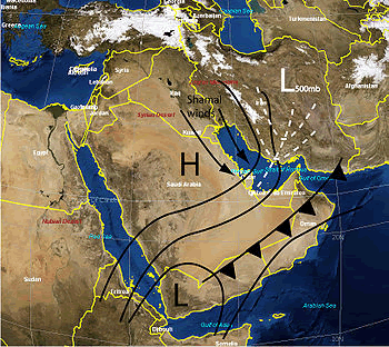
The Shamal Wind
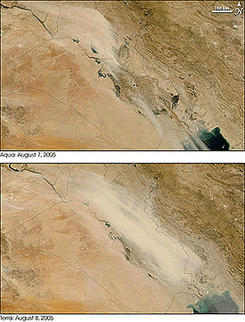
A shamal is a northwesterly wind blowing ofver Iraq and the Persioan Gulf states. It is often strong during the day but decreases at night. This weather effect occurs anywhere from once to several times a year, mostly in summer but sometimes in winter. The resulting wind typically creates a large sandstorm that impacts Ira, although most sand is picked up from Jordan and Syria. See the METSAT images below.
And the haboob wind which is locallized and much more difficult to forecast. This is a wind of thirty knots or more that occurs in a thunderstorm or strong rainshower. If you forecast these conditions in Iraq, forecast a sandstorm.
Click on the Voki below for the directions to the next exercise.